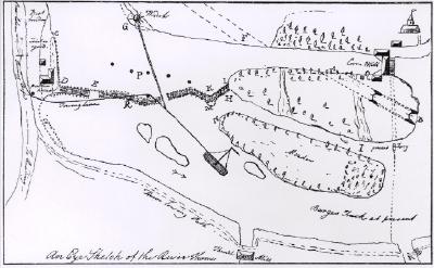
A photographic copy of a sketch of the River Thames at Pangbourne in 1786.
*This item was wrongly accessioned. It was disposed of after being removed from display as it was a copy of an image the Museum did not own rights to.*
Three photocopies of maps of Hammersmith, 1863, 1868 and 1922. Showing the positioning of the Creek at Hammersmith. Related to HBRC and collated by Jacqueline Finesilver.
A map showing the distribution of major Neolithic ceremonial monuments along the River Thames, including causewayed enclosures, cursus or related monuments, large ceremonial henges and concentrations of votive deposits.